Wind rose diagrams help you visualize wind patterns at a site. Use them to better inform your design decisions, but be aware of unique microclimates and site considerations that wind rose diagrams will not capture.
A "wind rose" diagram is the most common way of displaying wind data, and can be measured in a “speed distribution” or a “frequency distribution". Wind roses can be a yearly average, or can be made for specific seasons; some even include air temperature information.
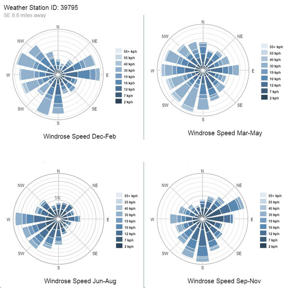 |
In Insight you can produce tri-monthly Wind Rose charts to observe how wind patterns change throughout the year. (But make sure this data is valid for your site. Wind can vary a lot by site and the provided weather data may not be accurate for you) |
|
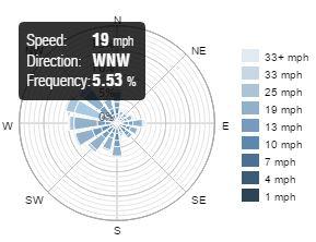
Wind Rose (Speed Distribution) This chart shows the frequency and speed of wind blowing from each direction. As you move outward on the radial scale, the frequency associated with wind coming from that direction increases. Each spoke is divided by color into wind speed ranges. The radial length of each spoke around the circle is the percentage of time that the wind blows from that direction. In this sample, Speed Distribution wind rose (an annual wind rose from Boston, Massachusetts), winds from the WNW direction is most common (more than 10% of annual hours). Of the winds from the WNW direction, wind speeds are most often in the 19 mph and 25 mph range. |
|

Wind Data
While weather data from software tools can provide a basic understanding of wind patterns, the best way to get accurate data is to perform real measurements at the site itself.
Climate data, including wind patterns, mostly comes from airports. It is often the case that the wind patterns measured at the airport are very different than the wind patterns of nearby sites. However, by understanding basic concepts of air movements, you can adjust the wind data to better suit the site location and simulate more accurate scenarios. When wind data is collected at airports, it is typically measured at 10 m (30 ft) above ground. Consider this and your terrain when designing with winds at a pedestrian level.