This project was an entrant in the January 2014 Excellence in Analysis Awards. The project explores the design decisions of a building built over 200 years ago and verifies whether or not they were the most energy efficient decisions. The project’s modeling process was so clearly articulated and actionable, we thought it deserved an honorable mention.
Project Scope

Design & Analysis Process
Creating a digital model for an existing building
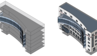
1. Photos of the structure were taken from all possible directions and an aerial view of the structure was taken from Google maps to help get the overall profile of the building, which is in the shape of letter “E.”

2. These images were then stitched together and edited to make every element of the building clear for modeling.
3. This enhanced .jpeg file was then inserted, as an image, into Revit, scaled and sized. The image served as template underlay and provided detailed information for each level that helped create the building model.

4. To complete the digital model, the site topography was created in a separate Revit file first, then added to the building model. There are not any surrounding buildings that could impact the building’s energy performance, so just topography was included.
Analysis preparation
1. Sun and shadow patterns were studied in Revit. For solar radiation analysis, Vasari was used. For orientation, thermal, and additional solar radiation analysis, Ecotect was used.
2. To move from Revit to Ecotect, the model was first exported as .FBX. It was then imported into 3ds Max to export as a .3DS mesh file. The 3D Studio Mesh file was imported into Ecotect without any geometry losses.

3. Once the geometry was imported into Ecotect, the site location was set and the weather data file selected.
Tips about Site Topography
- Site topography can be easily generated by using an exchange application available in Revit called CADtoEarth. This application allows you to pick the boundaries of the site in Google Earth and import the surface to Revit.
- Another way to accurately model a Toposurface is to use SketchUp Pro and select the site in Google Maps and export it as .DWG to import it into Revit.
More about the analyst
 |
Chinni Sumanth received a Bachelor of Civil Engineering from the College of Engineering at Anna University in Guindy, India. |